


2240-18
Almanac and Ephemeris Data
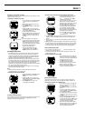
The data message sent from a GPS satellite consists of an almanac that
gives the approximate positions of all the other satellites in the system, and
the satellite ephemeris that contains precise information about the position of
the host satellite.
How quickly the watch is able to acquire the data it needs to determine your
position depends on a number of factors. One of the most important factors is
the status of almanac and ephemeris data in watch memory. There are two
possible data conditions from which you can start when performing a GPS
measurement: hot start, warm start.
Important!
• The above terms and their definitions are based on current standard
American English usage. Definitions may differ according to language and
geographic area.
Whenever the watch determines that the almanac data it currently has in
memory is no longer valid, it receives new almanac data from one of the
satellites overhead. The message “RECEIVING SATELLITE DATA” appears
when almanac data is being received. It takes about 10 minutes for this
procedure to be completed. Be sure to leave the watch with its antenna facing
the sky whenever this message is on the display.
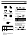
Factors that Affect GPS Signal Reception
Signal reception from GPS satellites may be difficult or even impossible under
the following conditions.
• Inside buildings or underground
• Among tall buildings
• In densely wooded areas
• Near high voltage lines
• Inside a motor vehicle
• When the antenna is covered by your sleeve, etc.
Navigation Precautions
• Never perform navigation operations while walking, cycling, or
operating a motor vehicle. Doing so can lead to accidents.
• Do not use this watch as a main navigation device for a boat or
aircraft. Doing so can lead to accidents.
• Though a useful navigational tool, a GPS receiver should never be
used as a replacement for conventional map and compass
techniques. Remember that magnetic compasses can work at
temperatures well below zero, have no batteries, and are mechanically
simple. They are easy to operate and understand, and will operate
almost anywhere. For these reasons, the magnetic compass should
still be your main navigation tool.
Data Reliability
• The global positioning system (GPS) is administered by the United States,
which also takes responsibility for all maintenance, management, and
precision adjustments. Because of this, there may be unforeseen changes
in the system and the signals it generates.
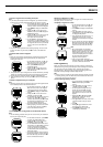
Graphical Navigation Screen
• Though the HEADING UP Screen can be used when traveling at speeds of
less than 8 kilometers per hour, measurement accuracy is greatly reduced.
• The message “SEARCH” appears on the screen if buildings or other
obstructions interfere with signal receipt while the HEADING UP Screen is
on the display during Continuous Mode measurements. The HEADING UP
Screen will return as soon as the next successful measurement is
achieved.
• The maximum distance that can be displayed on the Graphical Navigation
Screen is 9999 kilometers.
• The destination pointer may remain on the HEADING UP Screen even if
you come to a full stop.
• The appearance of the destination pointer changes automatically
depending on the relative direction of the destination.
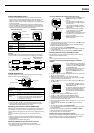
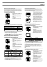
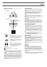
Bearing and Direction Values
Bearing and direction are indicated on the screens as values that represent
degrees. The following illustration shows the meanings of these values.
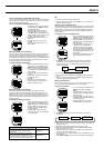
Display Indicators and Messages
The following describes some of the indicators and messages that appear on
the display of the watch. These are normal and do not indicate malfunction.
WAIT Message
This message appears on the display when you start charging after the
watch’s battery goes dead. Do not interrupt charging while this message is on
the display.
RECEIVING SATELLITE DATA Message
This message indicates that the watch is receiving satellite data. A data
receive operation can take about 10 minutes to complete. Leave the watch
with its face facing towards the sky during this period.
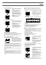
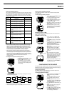
On-Screen Indicators
The following describes the indicators along the bottom of the display. The
following table explains what it means when there is a marker (bar) above an
indicator, which means the indicator is “on.”
Lower Display Area Items
The following table describes the types of information that appear in the lower
display area.
Note
• If 3D measurements were not possible for the last GPS measurement,
“____” is shown for both the altitude and the DOP value.
• “____” is shown for the distance to the destination if the distance is greater
than 9999 km.
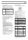
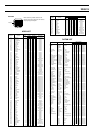
• GPS receiver circuit shut off for a very short time
(few minutes at most).
• Watch has not been moved to a different location
since last measurement.
• Both almanac and ephemeris data from last
measurement still in memory.
• GPS receiver circuit shut off for a long time (over
night, etc.)
• Watch has not been moved to a different location
since last measurement.
• Almanac data from last measurement still in
memory, but no ephemeris data.
Hot Start
Warm Start
Start Type Description
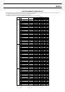
GPS
CONT
AUTO
2D
3D
ALM
SIG
BATT
Indicator Meaning When On
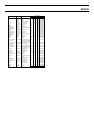
0° = North 45° = Northeast
90° = East
135° = Southeast
180° = South
225° = Southwest
270°= West
315° = Northwest
• Watch is in the GPS One-Shot or Auto Mode.
• This indicator is on when the watch is performing a
GPS measurement operation.
• Watch is in the GPS Continuous Mode.
• Watch is in the GPS Auto Mode.
• Watch is performing a 2-dimensional GPS
measurement (using three satellites).
• Watch is performing a 3-dimensional GPS
measurement (using four or more satellites), which
provides better accuracy than 2D.
• Daily alarm or arrival alarm is turned on.
• Hourly Time Signal is turned on.
• Battery power is low and battery needs to be
charged.
Display Item Content Screen Type
Longitude and
latitude
Stopwatch
Current time
and date
Heading and
Speed
Maximum
Speed
Altitude
Direction and
distance to
destination
DOP value
• S/N Latitude: Degrees, Minutes,
Seconds
• E/W Longitude: Degrees, Minutes,
Seconds
• Current year, month, day, hour,
minutes, seconds, AM/PM
• Continuous GPS measurement
mode only
• Heading (HDG): From 0° (due
north) to 359°,
• Speed (SPD): km/h
• Maximum speed (MAX SPD)
achieved
• Altitude (meters) obtained by GPS
measurement ALTI DOP value or
3D measurement
• Direction (BRG): Direction to
destination from 0° (straight) to
359°
• Distance (DIST): kilometers to
destination
• GPS measurement DOP value
Timekeeping,
Plot, Graphical
Navigation
Timekeeping
Position
Position, Plot,
Graphical
Navigation
Position, Plot,
Graphical
Navigation
Position, Plot,
Graphical
Navigation
Graphical
Navigation
Position