


2240-17
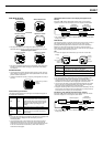
Satellite Information Display
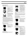
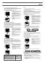
The following shows the meaning of the satellite marks that appear on the
display.
Satellite Marks
Searching
This mark indicates a satellite from which the watch
is standing by to receive a signal. The positions of
these satellites are determined using almanac data
for the current latitude, longitude, and time.
Tracking
This mark indicates a satellite that is currently being
tracked by the watch. Signal receipt for these
satellites is enabled.
Busy
This mark indicates a satellite from which ephemeris
data (information about the position of the host
satellite and the satellite clock time) is being
received. It indicates the satellites that the watch is
using for position measurement.
Battery Marks
: Battery charge is sufficient.
: Battery is getting load. Charge it as soon as possible.
Datums
Since the Earth is neither flat nor a perfect sphere or even an ellipsoid, a wide
variety of spheroid models (mostly ellipses) were developed with different
major and minor axes. An ellipsoid, in addition to the various control points
required to relate how the ellipsoid lies in relation to the Earth, constitutes a
map datum.
When various countries mapped their areas, each usually used its own datum
to provide accuracy in a specific area. Though some datums share the same
ellipsoid, they use different control points, which results in differing datums.
The development of air travel between countries created the need for a single
global datum, which is identified according to their World Geodetic System
(WGS) names. The constellation of GPS satellites uses WGS 84 to describe
coordinates. It should be noted that errors of several hundred meters can
occur if coordinates of one datum are referred to in another datum without
converting them first.
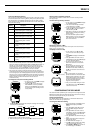
1
2
3
4
5
6
7
8
5
4
2
3
1
6
7
8
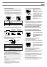
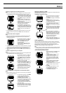
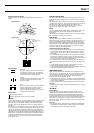
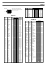
Zenith
West East
North
Horizon
South
Current latitude
and longitude
Celestial Sphere
Top-Down View
West
Horizon
North
Azimuth Angle
(Easterly from 0° due
north to 359°)
Zenith
East
South
UTM Grid Coordinates
The letters “UTM” stand for “Universal Transverse Mercator,” which is a grid
system developed in an attempt to set up a universal world wide system for
mapping.
The UTM system divides the earth into 60 zones, each of which is 6 degrees
of longitude wide. UTM zones, which extend from a latitude of 80° S to 84° N,
define the reference point for UTM grid coordinates within the zone.
You can find more about UTM grid coordinates from the many technical
subjects that are available on the topic, or on the Internet.
MRGS
The letters “MRGS” stand for “Military Reference Grid System,” which further
divides UTM grids into 100,000-meter grid squares with double-letter
designations.
You can find more about MRGS coordinates from the many technical subjects
that are available on the topic, or on the Internet.
DOP Values
The letters “DOP” stand for “Dilution of Precision,” and the DOP value
indicates the quality of the satellites available to you (geometry between you
and the set of satellites being used by the watch for measurement). A high
DOP value indicates poor satellite positioning, while a lower value indicates
better positioning. Taking a reading while the satellites being used are low on
the horizon or while you are under heavy tree cover produces a high DOP
value, which indicates poor satellite positioning.
How the Watch Uses the DOP Value
• When you perform a GPS measurement in the One-shot or AUTO Mode,
the watch obtains a DOP value for the positioning of the set of satellites
used for the measurement and compares it with the watch’s current DOP
value setting.
• If the obtained DOP value is greater than the preset DOP value (indicating
positioning that is poorer than the preset value), the watch beeps three
times and then continues to perform measurements until the obtained value
is less than the preset value or until 30 seconds elapse.
• If the watch is unable to achieve a measurement with a DOP value that is
less than the preset DOP value within 30 seconds, the watch beeps once.
Note
• The above DOP comparison operation is not performed when you are
using the Continuous Mode for GPS measurements.
• If you constantly experience problems obtaining successful GPS measurement
results, try increasing the watch’s DOP value setting.
USER MAG Setting
When you select magnetic north “USER MAG” in the procedure under “To
specify true north or magnetic north”, you must provide a magnetic declination
value that indicates the difference between true north and magnetic north at
your current location. You can obtain information about local magnetic
declination values from the following sources.
• Most topographic maps include a small diagram with three arrows showing
magnetic north, true north and Universal Transverse Mercator grid north, as
well as a value of declination.
• You can also find a wealth of magnetic declination information on the Internet.
Important!
• Magnetic declination values change year by year. Make sure you are using
current values.
GPS Mode
What is GPS?
The Global Positioning System (GPS) was originally developed and is
currently operated by the United States Department of Defense. The space
segment of the GPS consists of the NAVSTAR satellites that are orbiting
21,000 kilometers above the Earth over six equally spaced orbital planes.
When signals are received from a minimum of three satellites, the principal of
triangulation is used to determine the current location of the GPS Watch
based on the distance between each satellite and the watch, and the orbital
path of each satellite.
Important!
• The signals produced by GPS satellites are controlled by the GPS Master
Control Station at Colorado Springs, Colorado. Signals may be subject to
reduced precision and even interruption without notice.