


74
Global Positioning System (GPS) A satellite tracking system.
Heading (hea) Compass direction on the present course.
Knots (kt Velocity in nautical miles per hour.
Latitude Angular distance North or South of the Equator.
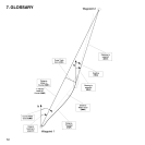
Lay line Optimal line towards a waypoint based on the wind direction.
Longitude Angular distance West or East of the prime meridian.
Nautical Mile One nautical mile equals 1852 meters.
Navigation Traveling between two locations on a route with knowledge of
the current location in relation to the route.
Position Exact map coordinates of a given location.
Tack Direction of the vessel in relation to the wind.
Tack angle difference (tad) A change in the tack angle caused by the wind.
Time to Lay line (ttl) Time to reach an optimal line towards a waypoint.
Time to Start line (tsl) Time to reach the start line based on the current velocity
and location.
Time of Sunrise (tsr) Estimated time to sunrise based on a GPS fix.