


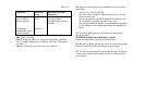

- Vertical angles up to 0.80 mils and elevation angles falling
within ± 0.40 mils may be read off the reticle with a
maximum accuracy of 0.05 mils.
8.7. To determine the polar coordinates, proceed as follows:
- Use the compass to orient the Angular Mount as directed
under 7.5.3;
- Aim the rangefinder to the object;
- Read the azimuth of the object;
- Range the object as directed under 9.3.
8.8. To convert the polar coordinates into rectangular
coordinates, proceed as follows:
- Take out the coordinate converter from the case;
- Release the clamp and detach the rule from the reverse side
of the plotting board;
- Determine the polar coordinates of the reference point and
the target as directed under 9.7 and note them down on the
plotting board or a special card;
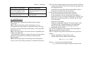
- Calculate from the determined magnetic azimuth A
m
of the
reference point and the target to find the directional angles,
reckoning in the compass correction ∆ A obtained from the
formula:
α = A
m
– ∆ A
m
- Read the compass correction ∆ A
m
of the map;
- Note down the reference point target directional angles on
the plotting board of card;
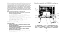
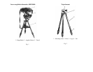
- 8. OPERATING PROCEDURE
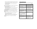
8.1. The rangefinder is designated to:
- Survey the ground;
- Range fixed targets;
- Range moving targets;
- Take azimuth and magnetic azimuth measurements;
- Take elevation and vertical angle measurements;
- Find polar coordinates of targets and reference objects;
- Convert the polar coordinates of the target and reference
object into rectangular coordinates, and find the target and
observation post coordinates from the predetermined
reference coordinates.
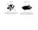
8.2. To use the rangefinder for ground surveillance, aim it with
hands roughly on the desired object, and then adjust it fine by
rotating the azimuth and elevation knobs.
8.3. For ground surveillance do the following:
- Set the ON-OFF selector switch to the ON position;
- Aim the rangefinder on the target so that it is observed in the
central gap of the reticle as close as possible to its centre,
and the screening objects (bushes, trees, terrain elevations,
etc.), which are located near the target or partially mask it,
are outside the gap. Locate the target in the lower portion of
the gap, touching the bottom mark of the reticle;
- Press the MEASURE 1 button, wait until the readiness
indicator comes on and release the button.
- Read the measured range. It will be displayed on the range
indicator for 3 to 5 seconds.