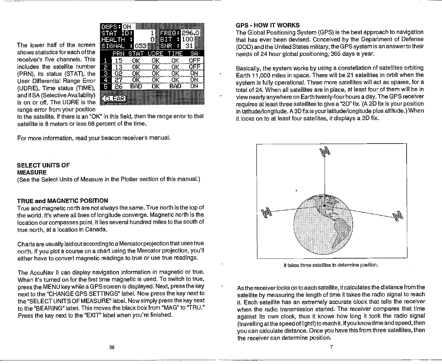
The lower half of the screen
shows statistics for each of the
receiver's five channels. This
includes the
satellite number
(PRN),
its status
(STAT),
the
User
Differential
Range
Error
(UDRE),
Time status
(TIME),
_______
and if SA
(Selective Availablity)
CLEAR
_________
is
on or off. The UDRE is the _____
range
error
from
your position
to the satellite. If there is an "OK" in this
field,
then
the
range
error to that
satellite
is 8 meters or less 68
percent
of the time.
GPS
-
HOW IT WORKS
The Global
Positioning System (GPS)
is the
best
approach
to
navigation
that has ever been devised. Conceived
by
the
Department
of Defense
(DOD)
and the United States
military,
the G PS
system
is an answerto their
needs of 24 hour
global positioning,
365
days
a
year.
Basically,
the
system
works
by using
a constellation of satellites
orbiting
Earth
11,000
miles in
space.
There will
be 21 satellites in orbit when the
system
is
fully operational.
Three more
satellites will act as
spares,
for a
total of 24. When all satellites are in
place,
at least
four of them will be in
view
nearly anywhere
on
Earthtwenty-four
hours a
day.
The OPS receiver
requires
at least three satellites to
give
a "2D"
fix.
(A
2D fix is
your position
in
latitude/longitude.
A 3D fix is
your
latitude/longitude plus altitude.)
When
it locks
on to at least four
satellites,
it
displays
a 3D fix.
For
more
information,
read
your
beacon receiver's manual.
SELECT UNITS OF
MEASURE
(See
the Select
Units of Measure in the Plotter section of this
manual.)
TRUE and MAGNETIC
POSITION
True and
magnetic
north
are not
always
the same. True
north is the
top
of
the world. It's
where all lines of
longitude converge. Magnetic
north is the
location our
compasses point.
It lies several hundred miles to the
south of
true
north,
at a location in
Canada.
Charts are
usually
laid out
according
to a Mercator
projectionthat
usestrue
north. If
you plot
a course on a chart
using
the Mercator
projection, you'll
either have to convert
magnetic
readings
to true or use true
readings.
The AccuNav
II can
display navigation
information in
magnetic
or true.
When it's turned
on for the first time
magnetic
is used. To
switch to
true,
press
the MENU
key
while
a GPS screen is
displayed.
Next, press
the
key
next to the "CHANGE
GPS SETTINGS" label. Now
press
the
key
next to
the "SELECT UNITS OF
MEASURE" label. Now
simply
press
the
key
next
to the "BEARING" label. This
moves the black box
from "MAO" to "TRU."
Press the
key
next to the "EXIT' label when
you're
finished.
As the
receiver locks on to each
satellite,
it calculates
the distance from the
satellite
by measuring
the
length
of time
it takes the radio
signal
to reach
it. Each
satellite has an
extremely
accurate
clock that tells the receiver
when the
radio transmission started. The receiver
compares
that time
against
its
own
clock,
thus it knows how
long
it took the radio
signal
(travelling
atthe
speed
of
lightl)
to reach it. If
you
knowtime and
speed,
then
you
can
calculate distance. Once
you
have this
from three
satellites,
then
the receiver
can determine
position.
11
15 OK 01<
OK OFF
13 OK OK OK OFF
02 OK OK OK ON
ë7 OK OK OK ON
26
BAD OK BAD ON
It takes three satellites to
determine
position.
38 7
PDF compression, OCR, web-optimization with CVISION's PdfCompressor