


10
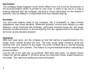
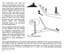
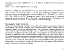
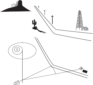
The instrument can also be
used for triangulation, see Fig 6.
The bearings obtained from the
main scale are 0° against the hill
and 64° against the curve of the
road, or 180° and 244° on the
reverse scale. Your own location
is indicated by the intersection
point of these two lines. When
performing very accurate posi-
tioning tasks the bearings
obtained have to be corrected
for local declination.
The co-tangent table at the back
of the Tandem can be utilized
for distance calculations, and
especially for locating position in
cases where two landmarks are
visible at a narrow angle. This
procedure is also illustrated in
Fig. 6.
The angle between the curve of the road and the oil derrick is 15°. A line is drawn at a
90° angle to the 64° bearing line from the curve of the road toward the oil derrick
bearing line. The distance, as measured on the chart, is 1.6 km [1 mile]. Then your
position is cot 15° x 1.6 km = 6 km [cot 15'° x 1 mile = 3.7 mile] along the corrected
bearing line of 64°.
t
0
°
64
°
15
°
90
°
Fig. 6. Triangulation